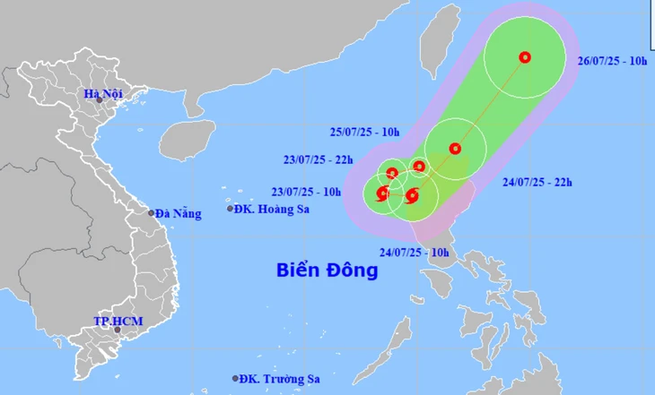
HCMC – A low-pressure system north of Luzon Island (Philippines) strengthened into a tropical depression on the morning of July 23 and is expected to enter the East Sea later today, according to the National Center for Hydro-Meteorological Forecasting.
At 10 a.m. on July 23, the center of the tropical depression was located over the northwestern waters of Luzon Island, with maximum sustained winds reaching level 6 (39-49 km/h) and gusts up to level 8.
The tropical depression is forecast to enter the East Sea this afternoon or evening. After entering the East Sea, it is expected to shift southwestward, then turn eastward, and eventually move northeastward out of the East Sea.
In terms of intensity, the tropical depression is likely to strengthen into a storm with wind speeds reaching level 8 within the next 24 hours, but it is unlikely to intensify further beyond that.
Due to the impact of the storm, the eastern waters of the northern part of the East Sea will experience strong winds of level 6-7, with areas near the storm’s center reaching level 8 and gusts up to level 10. Wave heights may reach 2 to 3.5 meters, creating rough sea conditions.
Earlier on the morning of July 23, the National Center for Hydro-Meteorological Forecasting reported that Storm Francisco, the seventh storm in the Northwest Pacific this year, had just formed off the coast of the Philippines at around 7 a.m.
Francisco is forecast to move toward the northern waters near Taiwan.
The tropical depression, which was previously downgraded from Storm Wipha (the third storm that has struck Vietnam this year), has further weakened into a low-pressure area over the Vietnam-Laos border region.
It is continuing to move mainly west-southwestward and is gradually dissipating.


