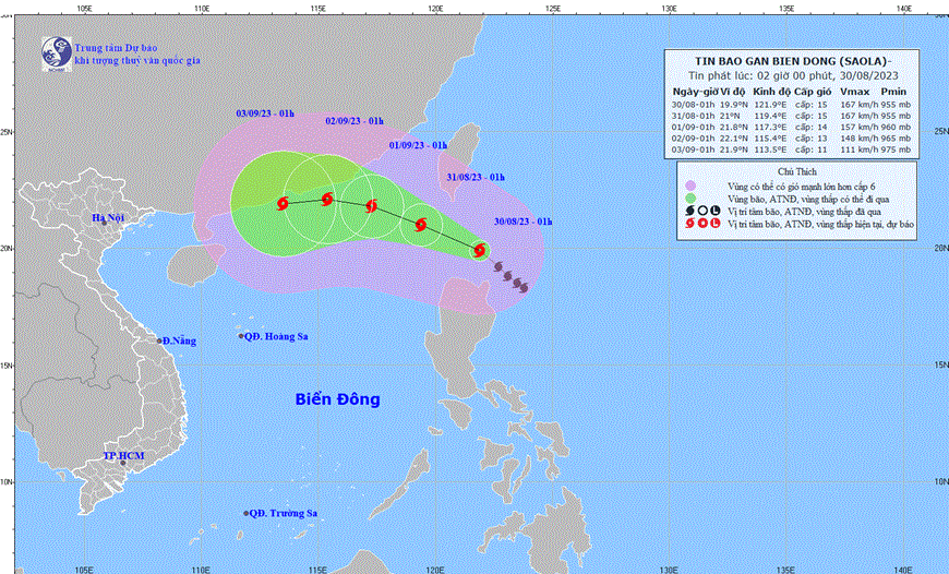
HCMC – The eye of the Saola storm was located over the sea near the northern Luzon island of the Philippines as of 1 a.m. today, August 30, with maximum wind speeds ranging from 167 to 183 kilometers per hour.
According to the National Center for Hydro-Meteorological Forecasting, the storm is projected to move in a northwest direction and enter the East Sea at around 1 a.m. on August 31, with a speed of 10-15 kilometers per hour. At this point, the storm’s maximum wind speed will be at level 15, with gusts reaching level 17, affecting the northeast of the North Sea region.
Until 1 a.m. on September 1, the Saola storm will maintain its west-northwest movement at a speed of 10 kilometers per hour, bringing a maximum wind speed at level 14 and gusts at level 17.
During the early morning of September 2, the storm will continue its west-northwest trajectory at a speed of 10 kilometers per hour. Wind speeds will decrease to level 13, with gusts at level 16, affecting the northern North Sea region.
Over the next 72 to 120 hours, the Saola storm will move westward at a speed of 10 kilometers per hour, and its intensity might gradually weaken.
The impact of the Saola storm is expected to bring strong winds and extremely rough seas to the northeast of the North Sea region starting from the evening of August 30. Maximum wind speeds are forecast to increase from level 6 to 13 or 15, and ocean waves are anticipated to reach heights of three to five meters in the region.


