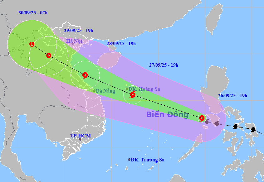
HCMC — Storm Bualoi entered the East Sea on the evening of September 26, becoming the 10th storm of the year. The storm is moving twice as fast as average storms and is forecast to directly affect Vietnam’s north-central coast, particularly Ha Tinh and Quang Tri provinces.
According to the National Center for Hydro-Meteorological Forecasting, at 7 p.m. on September 26, the storm’s center was about 900 km southeast of the Hoang Sa (Paracel) Islands. Maximum sustained winds near the eye reached 133 km/h (force 11–12 on the Beaufort scale), with gusts up to force 15. It was moving west-northwest at 30–35 km/h.
By 7 p.m. September 27, Bualoi is expected to pass over the Hoang Sa area with winds of force 12–13, gusting to force 16. By 7 p.m. September 28, the storm will reach the waters between Nghe An Province and Hue City, with winds at force 13 and gusts at force 16. It will then move inland over Ha Tinh and Quang Tri, weakening into a tropical depression in northern Laos.
Maritime and coastal impact
The storm brought strong winds and high seas across a wide area. From the evening of September 26, northern and central East Sea waters, including Hoang Sa, would saw winds at force 6–7, rising to force 8–9. Areas near the storm’s path experienced winds of force 10–13 and gusts up to force 16, with waves of 6–10 meters.
From the evening of September 27, seas between Thanh Hoa and Quang Ngai, including Hon Ngo Island, Con Co, and Ly Son, will face winds rising to force 8–9, gusting to force 16, with waves reaching 5–7 meters. By the morning of September 28, the northern Gulf of Tonkin regions, including Bach Long Vy, Van Don, and Co To island,s will face winds of force 8–9 and gusts of force 11, with waves up to 5 meters.
Coastal areas from Thanh Hoa to north Quang Tri will see winds strengthen to force 8–9 from the afternoon of September 28, with gusts of force 10–12 near the storm’s core. Wind damage could topple trees, damage houses, and disrupt power systems.
Heavy rain and flood risks
From September 28 to 30, heavy rain is expected across northern and north-central Vietnam. Most areas will receive 100–300 mm of rainfall, with some localities exceeding 400 mm. Northern plains and Thanh Hoa–Ha Tinh could see 200–400 mm, with isolated areas above 600 mm. Storm surge of 1–1.5 meters is expected along the north-central coasts.
Government response
Prime Minister Pham Minh Chinh has issued an urgent directive for central agencies and local authorities from Quang Ninh to Khanh Hoa to prepare for Bualoi’s impacts. The order requires continuous monitoring, early warning dissemination, and proactive measures to ensure public safety and property protection.
Key priorities include securing vessels, evacuating vulnerable communities, protecting infrastructure, and safeguarding agricultural and aquaculture operations. Authorities are urged to complete evacuations by 9 p.m. on September 28 and consider school closures in affected areas.
At a meeting on preparation for the landfall of Storm Bualoi on September 26, Deputy Minister of Agriculture and Environment Nguyen Hoang Hiep stressed that Bualoi is an unusually dangerous storm. Unlike Storm Ragasa, which weakened before landfall, Bualoi is expected to strengthen as it approaches the coast. Its wide impact zone covers from Ninh Binh to Ha Tinh, with prolonged wind and rain. He warned against complacency, particularly in areas still recovering from earlier storms.
Major concerns include flash floods, landslides in mountainous regions, and safety risks for reservoirs and hydropower dams. Authorities have been urged to consider preemptive dam water releases to avoid overflow during heavy rainfall.
Military preparedness
Deputy director of the Rescue and Search Department, Major General Pham Hai Chau, confirmed that the Ministry of Defence has mobilized units from coastal military commands and prepared rescue operations. The focus is on alerting and relocating vessels along the coast from Mong Cai (Quang Ninh Province ) to Lam Dong Province. A forward command post will be set up in Military Zone 4.
Given the storm’s speed and size, authorities have been instructed to implement emergency measures earlier than usual, including imposing bans on sea activities up to 48 hours before landfall.
Experts warned that Bualoi could trigger “compound disasters” — strong winds, heavy rains, floods, and landslides. They stress the need for maximum readiness and prompt action to protect lives, property, and critical infrastructure.


