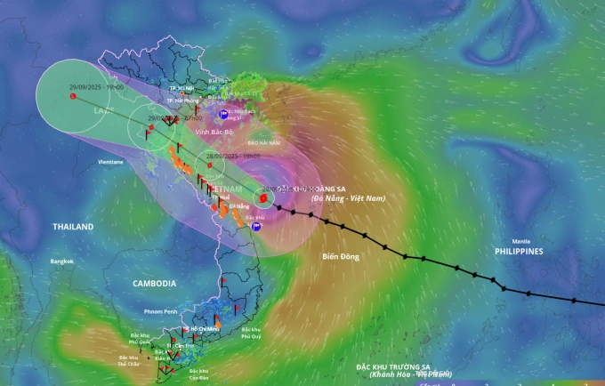
HCMC – Storm Bualoi is forecast to make landfall in the north-central provinces of Nghe An, Ha Tinh, and Quang Tri tonight, bringing destructive winds, heavy rainfall, floods and landslides.
The National Center for Hydro-Meteorological Forecasting reported that as of 4 a.m. today, the storm was located about 200 kilometers east of Danang, with sustained winds of up to 133 kilometers per hour and gusts reaching Category 15 on Vietnam’s wind scale. The storm is moving west-northwest at around 30 kilometers per hour.
By 4 p.m., Bualoi was over the waters off Nghe An and Quang Tri with winds at Category 12-13 and gusts up to Category 16. It is then projected to move inland, posing a Level 4 disaster risk on Vietnam’s five-tier scale.
By early tomorrow morning, the storm would weaken to Category 9-10 as it moves further inland over Thanh Hoa and Ha Tinh, before gradually dissipating into a tropical depression and low-pressure area over northern Laos.
Strong winds are expected to build up in the northern and central parts of the East Sea, including the Hoang Sa (Paracel Islands), with waves reaching 8-10 meters near the storm’s center. Coastal areas from Thanh Hoa to Quang Ngai, including Hon Ngu Island, Con Co and Ly Son special zones, may face winds of Category 10-13 and waves of 5-7 meters. In the northern Gulf of Tonkin, including Hon Dau Island, Bach Long Vi, Van Don, Co To, and Cat Hai special zones, waves could reach 3-5 meters. Storm surges of 0.5-1.5 meters are expected along coastlines from Ninh Binh to Ha Tinh, with the highest levels forecast for southern Thanh Hoa and northern Ha Tinh.
Onshore, strong winds of Category 6-7 with higher gusts will affect southern Quang Tri to Danang, while areas from Thanh Hoa to northern Quang Tri may experience winds up to Category 12 later today.
For the next three days, widespread rainfall of 100-300 millimeters is expected across northern Vietnam and provinces from Thanh Hoa to Quang Ngai, with localized totals exceeding 450 millimeters. In the northern delta, southern Phu Tho, Thanh Hoa, and northern Quang Tri, rainfall could reach 200-400 millimeters, with isolated areas receiving over 600 millimeters. Intense downpours of more than 200 millimeters within three hours are possible, raising the risk of flash floods and landslides in mountainous areas.
Rivers across northern Vietnam and the Thanh Hoa-Hue region could experience sharp rises, with water levels increasing by 5-9 meters upstream and 2-5 meters downstream. Major rivers are forecast to reach alert levels two to three, with some exceeding the highest warning level.
Low-lying areas along rivers and urban centers in northern Vietnam and the Thanh Hoa-Hue region face a high risk of widespread flooding, while mountainous areas are vulnerable to landslides.
Authorities are urging residents and local governments to take precautions and closely monitor updates as the storm approaches.


