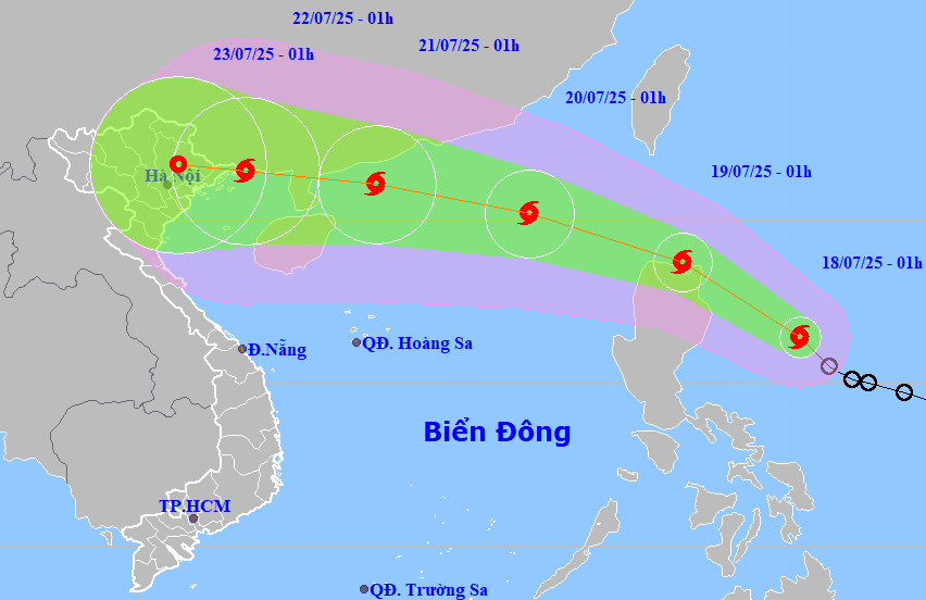
HCMC – The tropical depression over the eastern waters of the Philippines intensified into a storm early this morning (July 18), named Wipha internationally, and is expected to enter the East Sea tomorrow.
According to the National Center for Hydro-Meteorological Forecasting, as of 1:00 a.m. on July 18, Storm Wipha was located over the eastern waters of Luzon Island (Philippines).
The strongest winds near the storm’s eye were at level 8 (62-74 km/h), with gusts reaching level 10.
It is forecast to move mainly northwest over the next 24 hours at a speed of around 20 km/h and may continue to strengthen.
By 1:00 a.m. tomorrow, the center of Storm Wipha is expected to be over the northern waters of Luzon Island (Philippines), with wind speeds reaching level 8-9 (62-88 km/h) and gusts up to level 11.
The storm is forecasted to move quickly in a west-northwest direction at a speed of 20-25 km/h, with a high likelihood of entering the East Sea and continuing to strengthen. It is likely to become the third to affect Vietnam this year.
By 1:00 a.m. on July 20, the storm’s eye will be over the northern part of the East Sea, about 740 km east-southeast of the Leizhou Peninsula (China). The strongest winds near the center will reach level 10 (89-102 km/h), with gusts up to level 12.
During the day and night of July 20, Storm Wipha will maintain its speed and direction while continuing to strengthen. By 1:00 a.m. on July 21, the storm’s center will be located about 220 km east of the Leizhou Peninsula (China), with maximum sustained winds at level 11 (103-117 km/h) and gusts reaching level 14.
Starting this afternoon, under the influence of the storm, strong winds of level 6-7 and gusts up to level 9 are expected over the eastern part of the northern East Sea.
Waves will rise to 2.5-3.5 meters, resulting in rough sea conditions. Vessels in these hazardous areas may encounter thunderstorms, squalls, strong winds, and large waves.


