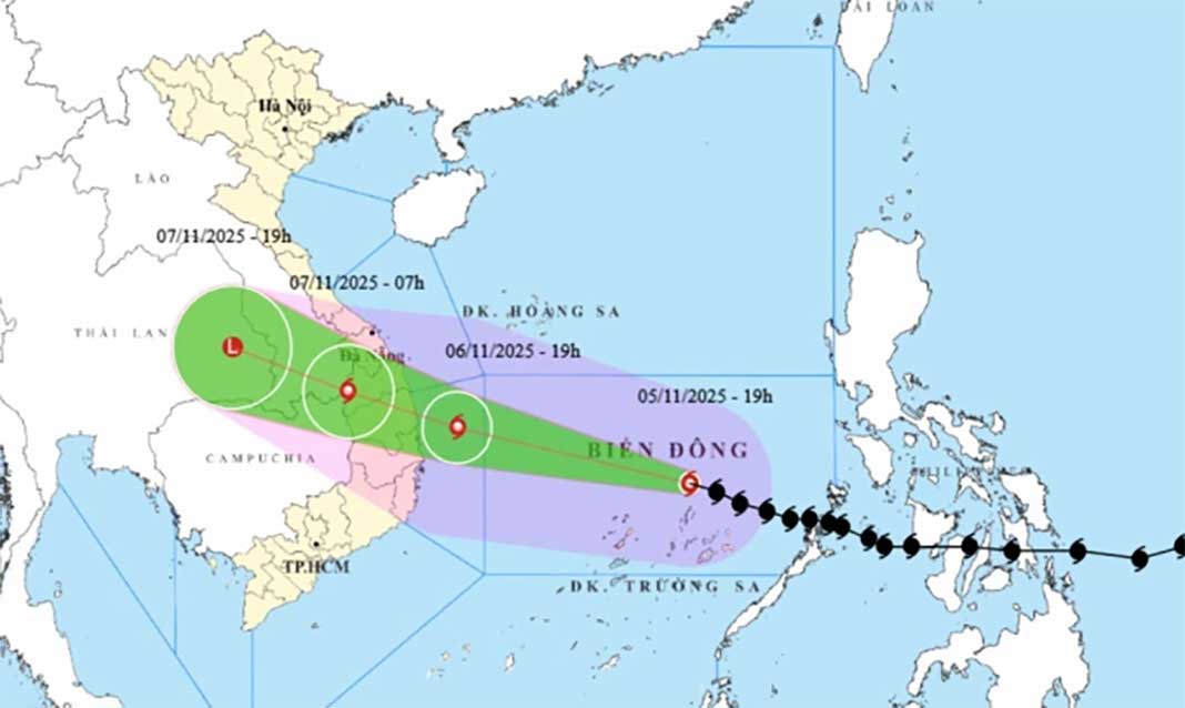
HCMC – Weather forecasters said that Dak Lak, Gia Lai, and Quang Ngai provinces would be the areas most affected by Typhoon Kalmaegi, where wind speeds may reach levels 10 to 12, with gusts exceeding level 15.
According to the National Center for Hydro-Meteorological Forecasting (NCHMF), as of 7 p.m. today, November 5, the eye of Typhoon Kalmaegi, the 13th storm to hit the country this year, was spotted about 240 kilometers east-northeast of Song Tu Tay Island of Vietnam’s Truong Sa (Spratly) Archipelago, and roughly 800 kilometers east-southeast of Quy Nhon, Gia Lai Province.
Winds near the center of the storm are blowing at level 14 (150–166 kilometers per hour), with gusts reaching level 17. The storm is moving west-northwest at around 25 kilometers per hour.
By the evening of November 6, the typhoon is expected to be about 120 kilometers east-southeast of Quy Nhon, maintaining level-14 strength with gusts of level 17, continuing west-northwestward at the same speed.
Forecasts indicated that Kalmaegi would make landfall between Danang City and Khanh Hoa Province late on November 6 or early on November 7.
By 7 a.m. on November 7, the storm is expected to move to the western border area of Quang Ngai Province and southern Laos, weakening to level 8 with gusts of level 10 while continuing west-northwest at around 25 kilometers per hour.
Due to the impact of this super-powerful storm, the central part of the East Sea (including the northern waters of the Truong Sa Archipelago which is a special zone of Vietnam) will see strong winds of levels 8–11; areas near the storm’s center will experience winds of levels 12–14, with gusts up to level 17 and waves rising 5–7 meters, reaching 8–10 meters near the eye of the storm, causing extremely rough seas.
From early November 6, strong winds are expected from the south of Quang Tri Province to Khanh Hoa (including Ly Son and Cu Lao Cham islands), increasing from levels 6–7 to 8–11, with waves 3–5 meters high; near the storm’s center, winds may reach levels 12–14 with gusts up to level 17 and waves 6–8 meters high, creating very rough seas.
The core impact zone is forecast to include Dak Lak, Gia Lai and Quang Ngai, where winds may reach levels 10–12 with gusts above level 15, possibly higher. The area of strong winds could expand further northward under the influence of a cold front.


