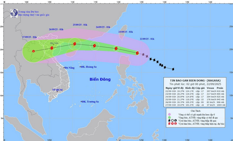
HCMC – Super typhoon Ragasa, with winds reaching levels 16–17 and gusts exceeding level 17, is approaching the East Sea, according to the National Center for Hydro-Meteorological Forecasting.
At 7 a.m. on September 22, Ragasa’s center was about 160 kilometers northeast of Luzon Island in the Philippines, with maximum sustained winds at level 17 (202–221 kph) and gusts above level 17. The storm was moving west-northwest at 20 kph.
The typhoon is causing winds in the northeastern East Sea to intensify to levels 8–9, later rising to 10–14. Areas near the storm’s eye may reach levels 15–17 with gusts above level 17, generating waves of more than 10 meters and extremely rough seas. Marine operations in these waters face high risks from strong winds, thunderstorms, and squalls.
By early September 23, the typhoon is forecast to enter the East Sea, possibly strengthening further to level 17 with gusts above level 17. The northern East Sea, including Vietnam’s Hoang Sa Islands (Paracels), will see winds strengthening to levels 10–14, with areas near the eye reaching 15–17. Seas may experience waves over 10 meters, posing risks even to large vessels.
In the Gulf of Tonkin, including Con Co, Bach Long Vi, and Co To islands, storm conditions are forecast from September 24 with winds at level 8, strengthening near the eye to levels 11–13 with gusts at 15–16, accompanied by thunderstorms and heavy rain.
By September 25, coastal waters from Quang Ninh to Ha Tinh are expected to see winds increasing to levels 9–10, and up to 12–14 near the eye, with waves of 4–7 meters threatening aquaculture farms and anchorage areas.
Authorities also warned of thunderstorms and squalls when the storm is still 300–400 kilometers offshore, urging beach areas from Quang Ninh to Hue and Danang to remain cautious of squalls linked to Ragasa’s circulation.


