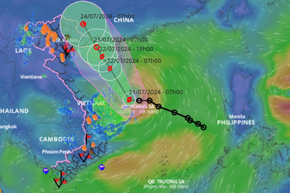
HCMC – A tropical depression in the East Sea has intensified into a typhoon, marking the second storm of this year in this region.
The typhoon is expected to hit Hainan Island, China, before moving towards the Gulf of Tonkin in northern Vietnam.
As of 7 a.m. today, Typhoon No. 2 was located over the waters near Vietnam’s Hoang Sa Islands. Maximum winds near the center of the typhoon reached level 8 (62-74 km/h), with gusts at level 10.
From Khanh Hoa to Binh Thuan, winds are forecasted to be at level 6, with gusts reaching level 7-8, causing rough seas.
Meteorological agencies anticipate moderate to heavy rainfall in northern Vietnam from July 22 to 25.
This afternoon and evening of July 21, the Central Highlands and southeastern Vietnam expect moderate to heavy rains accompanied by thunderstorms. Rainfall will vary widely from 20 to 50 mm, with some areas possibly exceeding 100 mm. The heavy rain is expected to ease at night.
Tonight, scattered showers and thunderstorms are expected in northwestern Vietnam with rainfalls ranging from 10-30 mm. Meanwhile, this afternoon and evening, southwestern Vietnam will experience scattered showers and thunderstorms with locally heavy rains of 15-30 mm.
The northern and central coastal regions of Central Vietnam will also experience scattered showers and thunderstorms. Some areas could receive heavy rainfall between 10 and 30 mm, with localized amounts exceeding 60 mm.
Authorities caution of potential flash floods and landslides in mountainous areas, as well as flooding in low-lying urban areas. Lightning, hailstorms, and strong gusts of wind are possible during thunderstorms.


